National Highways Authority of India (NHAI) plans to implement GNSS based ETC system within the existing FASTag ecosystem, initially using a hybrid model where both will operate simultaneously.
- Present system of FASTag is a Radio Frequency Identification (RFID) based ETC and is part of National Electronic Toll Collection Program.
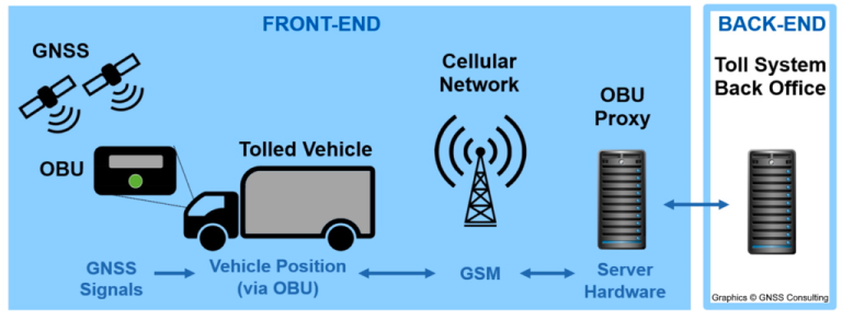
About GNSS based ETC
- It is a barrier free method of ETC which uses satellites or constellations of satellites to track vehicle’s movement and calculate tolls based on the distance travelled.
- Working
- Toll plaza will act as Stationary Enforcement Gantry identifying GNSS vehicles.
- A Centralized Toll Charger will be responsible for distance & toll calculation of GNSS vehicles travelling on GNSS stretch.
- Toll Charger will receive distance and time stamps of GNSS vehicles through On-board Unit (OBU) fitted on GNSS vehicles.
- OBUs will be onboarded with Toll Charger through issuer entities similar to issuer banks under FASTag system.
- Payment mechanism will be similar to FASTag system.
Significance of GNSS based ETC
- Barrier less free-flow tolling and distance-based tolling, thus reducing congestion.
- Help to plug leakages and check toll evaders.
- Modernization in toll collection systems in lines with global practices.