Why in the news?
Government of India is planning to pilot-test a Global Navigation Satellite System (GNSS)-based Electronic Toll Collection (ETC) system on national highways.
More on the news
- It will be implemented as an added facility along with the FASTag, which was made mandatory in January 2021.

About GNSS-based toll collection
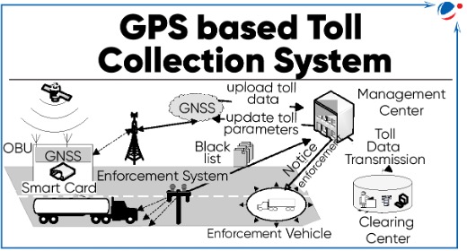
- Working: It uses satellite-based imaging to track the position of the vehicle and collect tolls based on the distance travelled.
- Main components:
- Online board Unit (OBU): GNSS-enabled device installed in a vehicle to determine vehicle route and calculate toll.
- Automatic number plate reader (ANPR) cameras: Installed on the highways to recognize vehicle's number plate and deduct toll money.
- ANPR uses optical character recognition on images to read vehicle registration plates to create vehicle location data.
- Benefits: Decrease the need for roadside tolling infrastructure; reduce congestion; enhance toll collection effectiveness, etc.
- Challenges: Signal interference or inaccurate readings; Privacy Concerns; need to equip older vehicles with GNSS technology etc.
- GNSS-based toll systems have already been implemented in countries like Germany and Singapore.
- India has its own satellite navigation systems, namely GAGAN (GPS-Aided GEO Augmented Navigation) and NavIC (Navigation with Indian Constellation).
Difference between FASTags & Satellite-based toll collection | ||
Parameters | FASTags | GNSS-based Toll collection |
Technology | 'Radio Frequency Identification' (RFID) | Satellite-based imaging and Automatic number plate reader (ANPR) cameras |
Equipment needed to be installed in Vehicles | FASTag (RFID Tag) affixed on the windscreen | OBU with GNSS connectivity |
Calculation of Toll tax | Fixed rates | Based on real-time vehicle movement data |
Requirement of Toll Plazas | Physical toll booths required for scanning FASTag | Not required |


