New Study Maps Flash Flood Prone Hotspots Across the Indian Subcontinent | Current Affairs | Vision IAS
MENU
Home

Periodically curated articles and updates on national and international developments relevant for UPSC Civil Services Examination.

Quick Links

High-quality MCQs and Mains Answer Writing to sharpen skills and reinforce learning every day.

Watch explainer and thematic concept-building videos under initiatives like Deep Dive, Master Classes, etc., on important UPSC topics.

ESC

The Study has found that flash floods are mainly centred in the Himalayas, the west coast, and Central India: Key Findings:

  • Extremely flash flood-prone sub-basins are located in the Brahmaputra, Narmada, Tapi, Mahanadi, Brahmani, and West Coast River basins.
  • High flash flood susceptibility is also observed in parts of the Godavari, Ganga, Mahi, and Indus River basins.

What are Flash Floods?

  • Definition: A flash flood is a flood of short duration with a relatively high peak discharge in which the time interval between the observable causative event and the flood is less than four to six hours (WMO, 2006).
  • Flash Floods and India:
    • Between 2020-2022, the number of flash flood events increased from 132 to 184 (Jal Shakti Ministry).
    • Every year, more than 5,000 people die due to Flash Floods

Key Drivers of Flash Floods

  • 25% Flash floods occur typically within six hours of heavy rainfall often triggered by cloudbursts. E.g., Himalayan regions.
  • Steep Topography and Narrow River Channels in Mountainous Regions: Facilitating rapid water accumulation and downstream surge.
  • Saturated Soil (due to concrete, roads): Water fails to percolate and results in sudden surface runoff.
  • Sudden release of dams, embankments, or check dams due to pressure buildup from upstream rainwater.

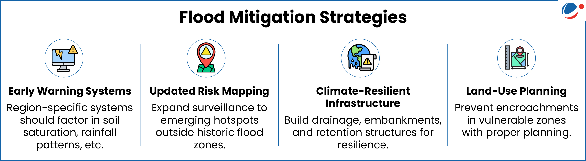
Flash Flood Guidance System (FFGS): A Tool for Early Warning and Risk Reduction

  • FFGS is a real-time early warning tool that provides 6–24-hour advance notice of flash flood threats.
  • Operational since 2020.
  • Part of a regional initiative for South Asian countries: India, Nepal, Bhutan, Bangladesh, and Sri Lanka.
  • Technical Features
    • Provides high-resolution forecasts with 4 km x 4 km spatial coverage.
    • Operates at watershed level, focusing on vulnerable Himalayan terrain and urban flash flood zones.
Watch Video News Today

Explore Related Content

Discover more articles, videos, and terms related to this topic

RELATED VIDEOS

2
Carbon Markets

Carbon Markets

YouTube HD
What is Artificial Rain? | Deep Dive With VisionIAS

What is Artificial Rain? | Deep Dive With VisionIAS

YouTube HD
Title is required. Maximum 500 characters.

Search Notes

Filter Notes

Loading your notes...
Searching your notes...
Loading more notes...
You've reached the end of your notes

No notes yet

Create your first note to get started.

No notes found

Try adjusting your search criteria or clear the search.

Saving...
Saved

Please select a subject.

Referenced Articles

linked

No references added yet

Subscribe for Premium Features