
Kalladi landslide in Waynad, Kerala has renewed concerns over landslide risks in India | Current Affairs | Vision IAS

Upgrade to Premium Today

Start Now
MENU
Home
Quick Links

High-quality MCQs and Mains Answer Writing to sharpen skills and reinforce learning every day.

Watch explainer and thematic concept-building videos under initiatives like Deep Dive, Master Classes, etc., on important UPSC topics.

A short, intensive, and exam-focused programme, insights from the Economic Survey, Union Budget, and UPSC current affairs.

ESC

In Summary

  • Waynad landslides linked to heavy rain, steep terrain, and fractured slopes in Western Ghats, similar to Himalayan incidents.
  • India is among the top 4 landslide-prone countries, with Northwest Himalayas being most affected, followed by Northeast Himalayas and Western Ghats.
  • GSI is the nodal agency for landslide mitigation; measures include hazard zonation mapping, structural stabilization, and early warning systems like LEWS by IIT Mandi.

In Summary

Waynad landslides has been linked to torrential rainfall, steep terrain and highly fractured slopes of Vellarimala mountain ranges in the Western Ghats.

  • Similar landslides incidents were reported from Himalayan states, like Uttarakhand (Chamoli) and Jammu & Kashmir.

About Landslides

  • It is the downward falling or sliding of a mass of soil, detritus, or rock on or from a steep slope under the influence of gravity
  • Landslide Atlas of India by ISRO
    • India is among the top 4 landslide-prone countries globally.
    • Excluding snow areas, ~12.6 % of area  is prone. 
    • Regional contribution: Northwest Himalayas - 66.5%, Northeast Himalayas -18.8%, Western Ghats - 14.7%.
Measures taken 

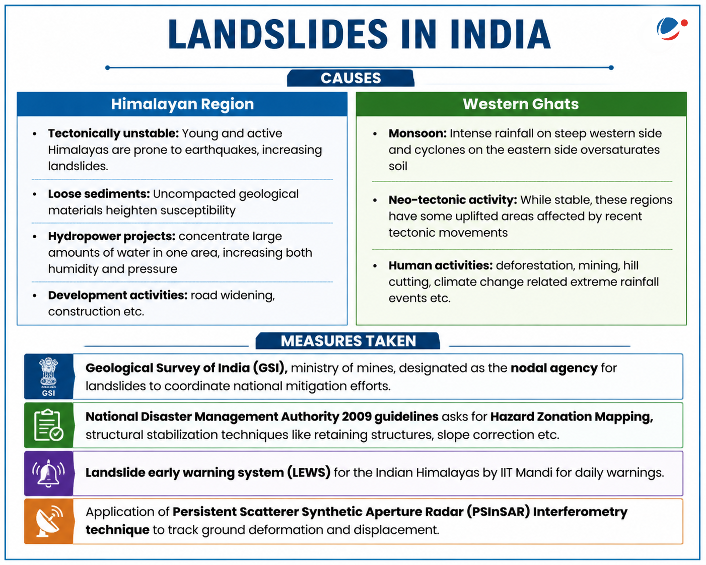
  • Geological Survey of India (GSI), ministry of mines, designated as the nodal agency for landslides to coordinate national mitigation efforts
  • National Disaster Management Authority 2009 guidelines asks for Hazard Zonation Mapping, structural stabilization techniques like retaining structures, slope correction etc. 
  • Landslide early warning system (LEWS) for the Indian Himalayas by IIT Mandi for daily warnings 
  • Application of Persistent Scatterer Synthetic Aperture Radar (PSInSAR) Interferometry technique to track ground deformation and displacement.
Watch Video News Today

Explore Related Content

Discover more articles, videos, and terms related to this topic

RELATED VIDEOS

3
News Today (Jul 31, 2024)

News Today (Jul 31, 2024)

YouTube HD
Landslides: Causes, Regions Vulnerable & Mitigation Measures (Wayanad, Sikkim Landslides)

Landslides: Causes, Regions Vulnerable & Mitigation Measures (Wayanad, Sikkim Landslides)

YouTube HD
Carbon Markets

Carbon Markets

YouTube HD

RELATED TERMS

3

Persistent Scatterer Synthetic Aperture Radar (PSInSAR) Interferometry

A remote sensing technique used to monitor ground deformation and displacement over time by analyzing radar images. It is crucial for identifying subtle ground movements that can precede landslides.

Landslide early warning system (LEWS)

A system designed to detect potential landslide events in advance and provide timely warnings to communities at risk, enabling them to take precautionary measures. IIT Mandi has developed such a system for the Indian Himalayas.

Hazard Zonation Mapping

A process of identifying and delineating areas prone to specific natural hazards like landslides, earthquakes, or floods. This mapping helps in land-use planning and risk reduction strategies.

Title is required. Maximum 500 characters.

Search Notes

Filter Notes

Loading your notes...
Searching your notes...
Loading more notes...
You've reached the end of your notes

No notes yet

Create your first note to get started.

No notes found

Try adjusting your search criteria or clear the search.

Saving...
Saved

Please select a subject.

Referenced Articles

linked

No references added yet