
Delhi government will overhaul State Action Plan on Climate Change (SAPCC) originally adopted in 2019.
- Delhi’s action plan needs revision amid intensifying extreme weather (E.g. unprecedented heat waves and record rain this year).
SAPCC
- States/UTs prepare respective SAPCC to address state-specific issues related to climate change through adaptation & mitigation measures.
- SAPCCs are context specific, considering different ecological, social, and economic conditions of each State.
- SAPCCs are in line with National Action Plan on Climate Change (NAPCC).
- NAPCC, released in 2008, outlines a national strategy for India’s climate change adaptation.
- There are eight National Missions which form the core of NAPCC.
- Funding: Made under Climate Change Action Plan scheme.
- Status: 34 States / UTs have so far prepared their SAPCC.
Barriers to implementation
- Lack of leadership and political will because of SAPCC’s top down approach & already existing climate change strategies/plans.
- Lack of clear actions (Not specific and clear enough to facilitate implementation)
- Resource constraints as State assumed that funding would come from central government/elsewhere.
Way forward
- International climate finance could potentially cover additional costs of adaptation.
- Nominating nodal officers (For addressing institutional bottleneck) within each key department to act as a focal point for climate change.
- Developing detailed project reports & Regular updation of plan.
Article Sources
1 sourceUttarakhand has become the first Indian state to launch a Gross Environment Product Index (GEPI).
About GEPI:
- GEPI is a novel method to evaluate ecological development caused by human interventions.
- Four pillars of GEPI: Air, soil, tree and water.
- Formula:
- GEP index = (Air- GEP index + Water- GEP index + Soil-GEP index + Forest-GEP index)
- Significance:
- Help assess the impact of anthropological pressure on our ecosystem and natural resources.
- Also calculates what we put back into the environment.
- Quantifies contributions of natural ecosystems to the economy and overall welfare.
It highlights that climate change intensifies extreme weather, disrupts schooling and causes learning losses and dropouts.
Impact of Climate Change on Education
- Education Remains Overlooked in Climate Policy Agenda: In 2020, education accounted for less than 1.3% of climate assistance and was mentioned in less than one in three Nationally Determined Contribution plans.
- School Closures: Over 2005-2024, schools were closed in at least 75% of extreme weather events, impacting 5 million people or more.
- Over 99 % of children across world are exposed to atleast one major climate and environmental hazard, shock.
- Rising temperature negatively impact learning outcomes: Even an increase of 1°C in outdoor temperature on exam days can result in a substantial decline in test scores.
- E.g. Students in hottest 10% of Brazilian municipalities, lost about 1% of learning per year due to increasing heat exposure.
- Increasing food insecurity and economic fragility jeopardize school enrollment: Up to 170 million people will be at risk of hunger by 2080 due to climate change, affecting student learning.
- Disproportionate harm: Climate-related events prevent at least 4 million girls in low- and lower-middle-income countries from completing their education.
Approach to adapt education systems for climate change
|
Article Sources
1 sourceAzerbaijan launches Climate Finance Action Fund in Package of Initiatives for UN Climate Change Conference COP29.
About CFAF
- Headquarter: Baku, Azerbaijan.
- Fund will support climate projects in developing countries, meeting next generation of Nationally Determined Contributions (NDCs) to keep 1.5 0C within reach, and addressing the consequences of natural disasters.
- CFAF will be capitalised with contributions from fossil fuel producing countries and companies across oil, gas and coal.
- CFAF will become operational at the conclusion of the initial fundraising round ($1 billion), and when 10 contributing countries will commit as shareholders.
Recently, the EU Nature Restoration Law came into force.
About the Law
- EU’s first continent-wide legislation for nature restoration.
- Aim: Restore 20% of degraded ecosystems by 2030 and all by 2050.
- Requires Member States to prepare National Restoration Plans by 1 September 2026.
- Prioritizes conservation of Natura 2000 network areas.
- Natura 2000 is a network of protected areas in EU.
- Legally binding targets:
- Restore 30% of terrestrial, coastal, freshwater, drained peatlands, and marine ecosystems by 2030.
- Restore 25,000 km of rivers to free-flowing status.
- Plant three billion additional trees by 2030.
Article Sources
1 sourceExperts called for “Recognition of Aquatic Deoxygenation(AD) as a New Planetary Boundary”.
- AD is overall decline in the oxygen content of oceanic and coastal waters (happens when oxygen consumption is greater than oxygen replenishment).
Status of AD
- Ocean: About 2% of oxygen content in ocean has been lost since 1960s.
- More than 500 low-oxygen sites have been identified in coastal waters.
- Other water bodies: Lakes and reservoirs have experienced oxygen losses of 5.5 and 18.6 % respectively since 1980.
Reasons underscoring AD
- Global Warming caused by GHG: Rise in temperatures decreases solubility of oxygen in water.
- Also, warm surface layers in ocean prevent oxygen from mixing deeper into ocean (leading to low oxygen level in deep sea waters)
- Eutrophication: Nutrient over enrichment from anthropogenic sources (e.g. agriculture) leads to algal blooms and increased consumption of oxygen.
Impact on Ecosystems
- Occurrences of dead zones and ocean hypoxia effect
- Habitat compression (reducing quality and quantity of suitable habitat) for fisheries leads to reduced biomass, species loss.
- Affects regulation and modulation of Earth's climate (due to production of GHGs by microbiotic processes in such regions)
- Changes in marine food web due to increased risk of predation, and other factors e.g. Ocean acidification.
Planetary boundaries
|
Article Sources
1 sourceThese wetland include
Wetland | Specifications |
Nanjarayan Bird Sanctuary (Tamil Nadu) |
|
Kazhuveli Bird Sanctuary (Tamil Nadu) |
|
Tawa Reservoir (Madhya Pradesh) |
|
About Wetland
- An area of land that is saturated with water.
- Wetland must meet at least 1 of 9 criteria like regularly supports 20,000 or more water birds, or conserving biological diversity etc.
- Now, total Ramsar Sites in India is 85. Tamil Nadu has maximum Ramsar Sites.
Article Sources
1 sourceReport was released on World Mangrove Day (observed annually on 26th July) by Global Mangrove Alliance.
Key Highlights of Report
- Southeast Asia has about one-third of all mangroves globally (Indonesia alone has 21% of world’s mangroves), followed by West and Central Africa.
- Half of world’s mangrove provinces are considered threatened (IUCN Red List of Mangrove Ecosystems).
- Mangroves in Lakshadweep archipelago and on coast of Tamil Nadu are critically endangered.
- Drivers of Mangrove Loss:
- Climate change (sea-level rise, increased storm intensity).
- Expansion of industrial shrimp aquaculture (Andhra Pradesh, West Bengal, Gujarat).
- Conversion to oil palm plantations, rice cultivation (43% loss between 2000- 2020).
Click here to know more about Mangroves.
Article Sources
1 sourceAgharkar Research Institute has described India’s first cultures of indigenous methanotrophs named Methylocucumis oryzae.
- Name ‘methane eating cucumbers’ has been given to this novel genus.
About Methanotrophs (Methane-utilizing bacteria)
- These bacteria oxidize methane and build up their biomass.
- Habitat: Wetlands, rice fields, ponds and other water bodies
- Biofiltering: These bacteria can oxidize methane produced in anaerobic environments.
- When oxygen is present in soils, atmospheric methane is also oxidized.
- These bacterias are natural methane mitigating agents.
- Significance: Tackling Global Warming by reducing methane concentration in soil & atmosphere.
Article Sources
1 sourceA new flowering plant from Ceropegia genus called Ceropegia Shivrayiana has been discovered in Vishalgad area of Kolhapur.
- Plant has been named after Chhatrapati Shivaji Maharaj.
About Ceropegia Shivrayiana
- Rare plant endemic to India and has unique, tubular flowers that attract moths.
- Habitat: Rocky places & can survive in soil with few nutrients.
- Family: Asclepiadaceae family, which includes many medicinal plants.
- Similarity: Species is similar to Ceropegia lawii Hooker f., but differs in having a climbing habit, hairy peduncles etc.
- Threat: Habitat loss
It has been included on the IUCN (International Union for Conservation of Nature) official Red List of threatened species under the Vulnerable category.
Neelakurinji (Strobilanthes kunthiana)
- About: Shrub known for massive blooming every 12 years. Semelparous, i.e., single reproductive episode before death.
- Location: Shola grasslands of Western Ghats - the Nilgiri hills, Palani hills and the Eravikulam hills of Munnar, also Shevaroy hills in the Eastern Ghats.
- The name Nilgiris (blue mountains) was derived from the colors of these flowers.
- Major Threats: Tea and softwood plantations, urbanization, invasion of exotic species like eucalyptus, black wattle, etc.
India has taken over the Chair of ADPC from People Republic of China for the year 2024-25.
About ADPC
- Autonomous International Organization for cooperation in and implementation of disaster risk reduction and building climate resilience in Asia and the Pacific region.
- India and eight neighbouring countries are the founding members of ADPC.
- It was established in 1986 as a regional disaster preparedness center (DMC) in Bangkok, Thailand.
Article Sources
1 sourceAfter 2 decades, FAO updated its IFM voluntary guidelines for managing wildfire risks.
- The new guidelines are prepared by Global Fire Management Hub (GFMH) which was launched by FAO and UNEP in 2023.
Key Principles of IFM
- Economic: Maximize benefits and minimize wildfire losses by implementing an efficient IFM program.
- Environmental: Consider interactions between climate change, vegetation, and fire regimes in fire planning and management.
- Equity: Consider the impacts of fire from all stakeholder perspectives, including gender, as wildfires can affect them differently.
- Human health: Use early detection and warning systems to reduce health impacts and adapt fire danger ratings with reliable weather forecasts.
Key Strategic Action of IFM
- Integrated Fire Management: Take action before, during, and after a fire while avoiding the introduction of invasive species through fire suppression and equipment.
- Planned fire: It is a component of wildfire prevention and involves allowing some fires to burn within defined parameters in fire-dependent ecosystems.
- Fire Awareness Programmes: Develop programs that respect cultural and social norms, including the use of fire for agriculture, forestry, and traditional purposes.
- Knowledge transfer: Collaborate with scientists, Indigenous Peoples, and local experts to enhance policies, regulations, and practices.
Article Sources
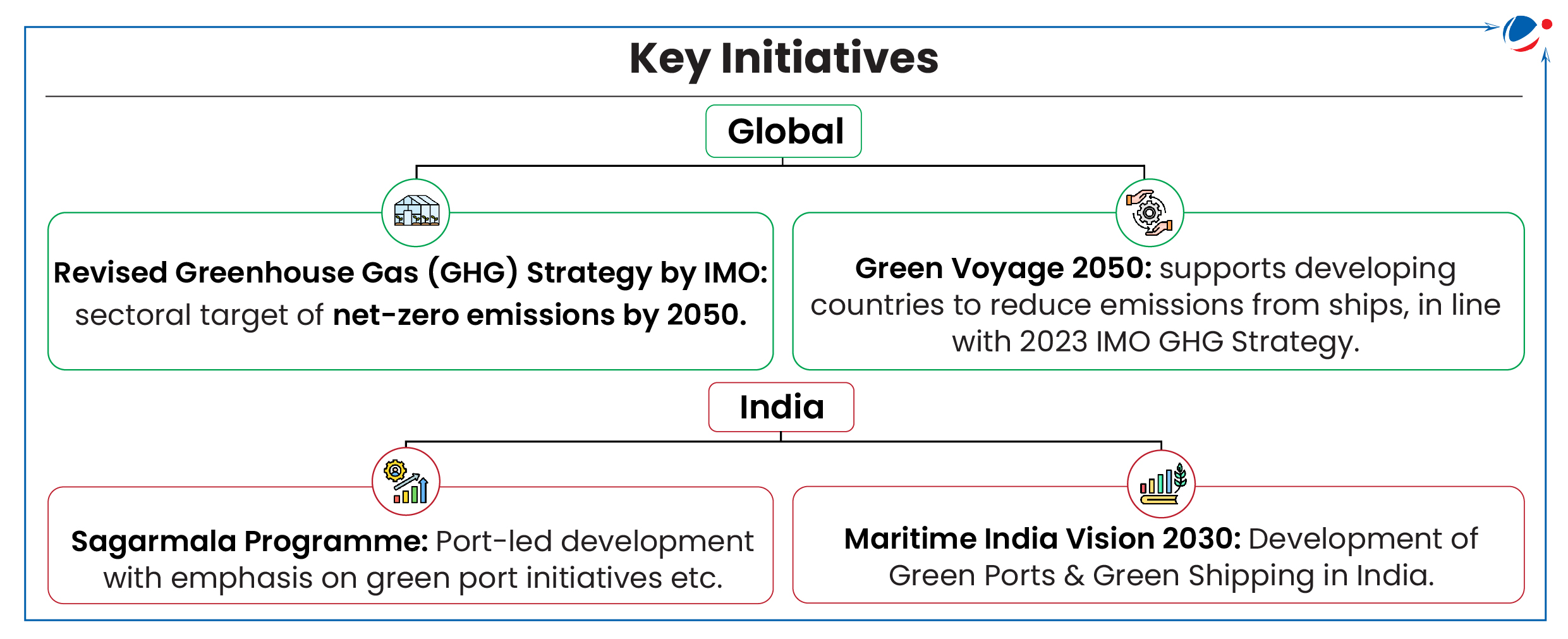
1 sourceUnion Minister of Port Shipping and Waterways launched the SOP for GTTP to drive the transition from conventional fuel-based harbour tugs to greener, more sustainable alternatives towards Green shipping.
- A tug is a particular class of boat which helps mega-ships enter or leave a port.
About GTTP
- GTTP, announced in 2023, is a key initiative under the ‘Panch Karma Sankalp’ to phase out conventional fuel-based harbour tugs operating in Indian Major Ports and replace them with green tugs.
- ‘Panch Karma Sankalp’ includes 5 major announcements including 30% financial support for the promotion of Green Shipping, Single Window Portal to facilitate and monitor river and sea cruises, etc.
Need of Green Shipping
- Shipping sector accounts for nearly 3% of world's CO2 emissions.
- For India, GHG emissions from maritime (excluding military operations) contribute 1% of overall transport sector GHG emissions.
Challenges in Decarbonization of Shipping
- High Dependency on fossil Fuels: About 99% of energy demand from the international shipping sector is met by fossil fuels.
- Transition cost: e.g., For use of LNG fuel, it requires extensive retrofits to existing infrastructure as it require storage of fuel at cryogenic temperatures.
- Others: Inadequate port facilities resulting in sub-optimal route planning and inefficient fuel consumption, difficulty in enforcing regulations in international waters, etc.
Article Sources
1 sourceWorld Meteorological Organization has launched the PCAPS project to improve weather forecasting in Arctic and Antarctic.
About PCAPS
- Objective: To increase and improve weather, water, ice, and climate information about the Arctic and Antarctic.
- It will help develop observation systems and Earth system models and advocate for improved forecasting services.
- PCAPS is part of WMO's World Weather Research Programme (WWRP).
WMO’s WWRP
- Key Objectives:
- Advance research of the earth system through the science-for-services value cycle approach
- Improve the warning process to account for the evolving nature of extreme weather impacts
Article Sources
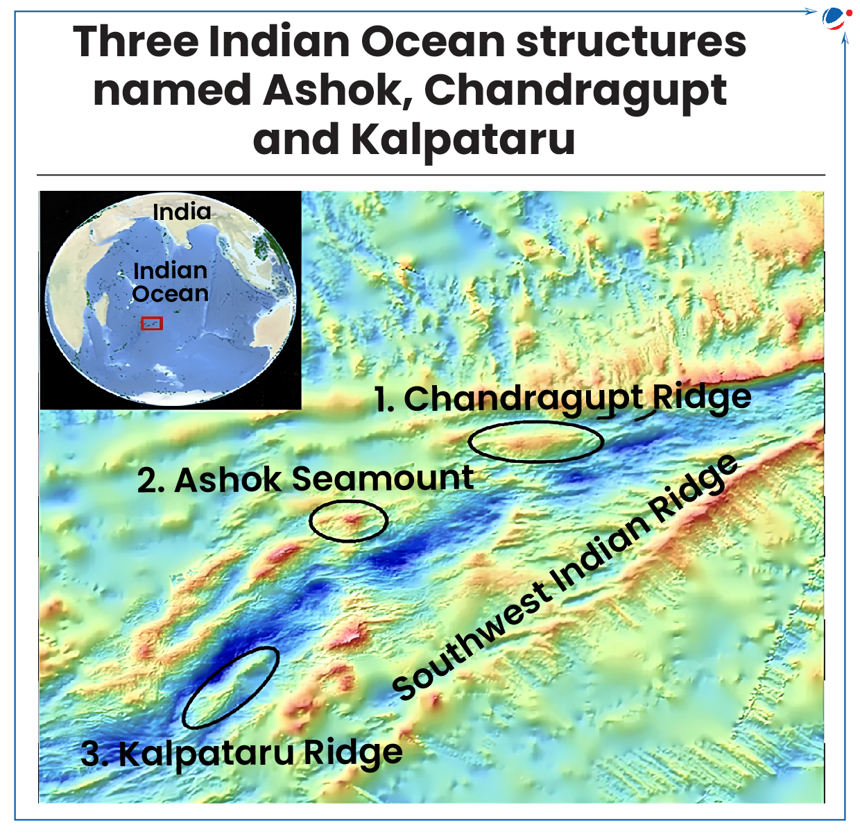
1 sourceNames of Ashok Seamount, Chandragupt Ridge and Kalpataru Ridge in the Indian Ocean have been approved by IHO and UNESCO’s IOC.
- These structures are located along Southwest Indian Ridge.
- They were discovered by National Centre for Polar and Ocean Research.
Naming of Undersea Feature
- Outside Territorial Sea:
- Individuals and agencies can propose names for unnamed features, following IHO’s 2013 guidelines ‘‘Standardization of Undersea Feature Name”.
- Before naming of a feature, its character, extent, and position must be identified.
- Proposals are reviewed by IHO Sub-Committee on Undersea Feature Names (SCUFN).
- Within Territorial Sea: National authorities naming features in their territorial sea should adhere to the same 2013 IHO guidelines.
About IHO and IOC
- International Hydrographic Organization (IHO)
- Established in 1921.
- An intergovernmental body (India a member).
- Enjoys observer status at the UN.
- Recognized as competent international authority regarding hydrography and nautical charting.
- Intergovernmental Oceanographic Commission (IOC)
- Established in 1961.
- Promotes international cooperation in marine sciences.
- GEBCO: General Bathymetric Chart of the Oceans (GEBCO) is an IHO & IOC UNESCO joint project to collect bathymetric data and map the oceans
- GEBCO -SCUFN maintains and makes available a digital gazetteer of the names, generic feature types, etc.
Article Sources
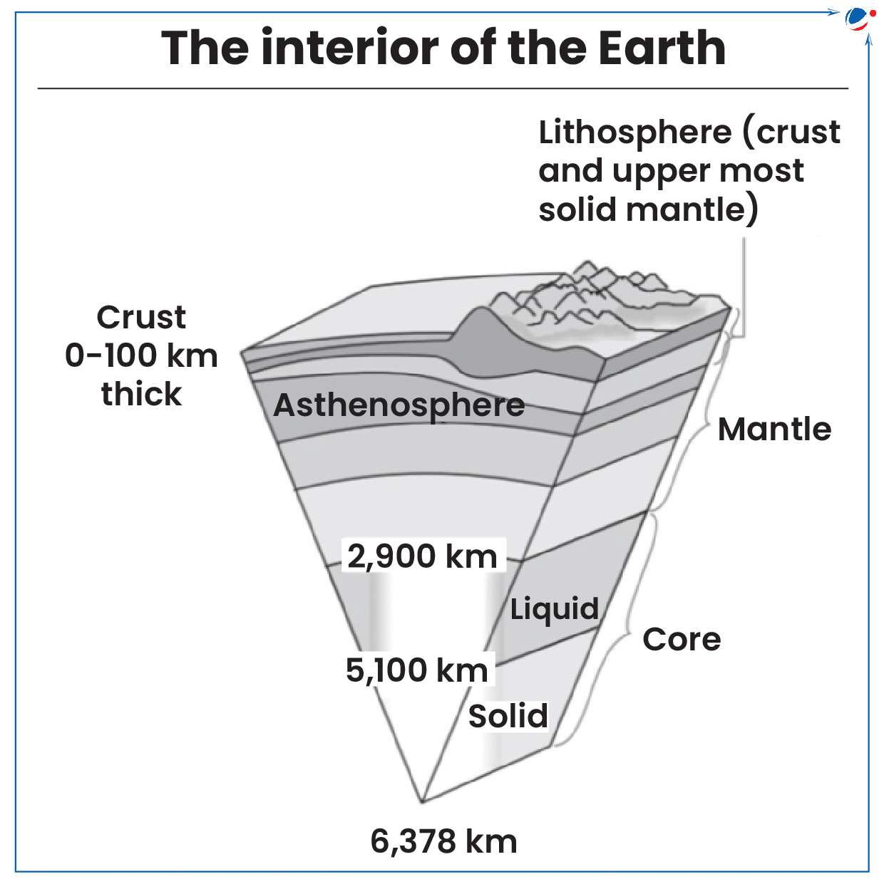
1 sourceScientists on the US vessel JOIDES Resolution have drilled around 1.2 Kms meters below the Atlantis Massif, surpassing the previous drilling depth of 201 meters.
- Mantle consisting of silicate rock makes up over 80% of Earth's volume is the mid layer of the earth (Refer infographic).
- Mantle rocks are usually inaccessible, except in areas of seafloor spreading, where Earth's tectonic plates slowly move apart.For example, the Atlantis Massif.
- Atlantis Massif is an underwater mountain near the Mid-Atlantic Ridge.
Key highlights
- Programme: Drilling was done under International Ocean Discovery Program (India is a funding partner).
- Location: The drilling was done on the southern side of the Atlantis Massif, near the Lost City Hydrothermal Field.
- Sample recovered: The new rock sample contains over 70% rock.
- Significance:
- Samples helps us understand
- upper mantle's composition
- chemical reactions between these rock and seawater over a range of temperatures
- Samples helps us understand
- These processes might have played a role in the origin of life on Earth billions of years ago.
- Also, previous drilling was not deep enough to look for organisms such as heat-loving bacteria that might dwell farther down.
Article Sources
1 sourceScientists warn that intensification and increased frequency of atmospheric rivers due to global warming is worsening extreme rainfall events and weather patterns.
Atmospheric rivers (AR)
- AR, also called as ‘flying rivers’, are relatively long, narrow regions in the atmosphere that transport most of the water vapour outside of tropics.
- An average AR is about 2,000 km long, 500 km wide and nearly 3 km deep.
- ARs are a part of larger system of extratropical cyclones that transport heat and moisture from tropics toward the poles.
- ARs are typically located within low-level jet, an area of strong winds in lower atmosphere.
- They are largest transport mechanisms of freshwater on Earth, responsible for 90% of moisture transfer from tropics to poles.
- While many ARs are weak systems, some larger and strong ARs can create extreme rainfall and floods, causing mudslides and catastrophic damage.
Climate Change and Atmospheric Rivers
- With temperature increase, intensity of rain events rises because of increase in atmosphere’s moisture retention capacity.
- By 2100, ARs are predicted to become more intense globally and will be much broader and longer.
- Intensified ARs can produce drought like conditions by removing rainfall from rainfall-dependent regions.
Impact of ARs on India
|


