
Why in the News?
'Sea level rise scenarios and inundation maps for selected Indian coastal cities' titled report was published by a Bengaluru-based think tank, the Centre for Study of Science, Technology and Policy (CSTEP).
Key Observation
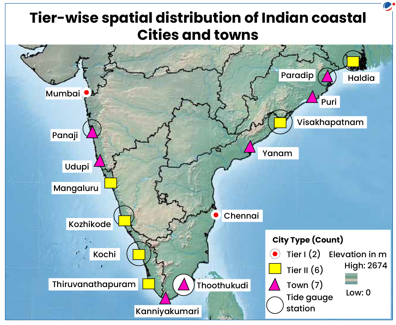
- Maximum Sea Level Rise (SLR): Maximum SLR over the past three decades (1991–2020) was observed at the Mumbai station (4.44 cm), followed by Haldia (2.72 cm), Visakhapatnam (2.38 cm), etc.
- Submergence due to rise in sea levels by 2040: More than 10% of the land in Mumbai, Yanam, and Thoothukudi; 5%–10% in Panaji and Chennai; and 1%–5% in Kochi, Mangaluru, Visakhapatnam, Haldia, Udupi, Paradip, and Puri would be submerged due to rise in sea levels by 2040.
Factors for Sea Level Rise (SLR)
- Ocean thermal expansion: Oceans absorb more than 90% of the heat trapped by accumulating greenhouse gases (GHGs), leading to temperatures increase and expansion of water.
- Ice melting: The melting of ice from glaciers, ice caps, and ice sheets in Greenland and Antarctica is another cause of SLR.
Impacts of Sea Level Rise
- Increased coastal erosion: As the sea level rises, more frequent and extreme coastal floods and storm surges occur, which increase coastal erosion.
- For instance, as per National Centre for Coastal Research (NCCR) report around 32 per cent of India's coastline underwent sea erosion between 1990 and 2018.
- Coastal inundation and flooding: Rising sea levels increase the risk of frequent and severe floods and inundation in low-lying coastal regions and islands.
- Freshwater salinization: Freshwater sources, such as subterranean aquifers and river deltas, are susceptible to salinization due to SLR.
- Coastal community displacement: Low-lying coastal communities are at risk of land flooding due to SLR.
- For example, as around 3.6 million people have been displaced in South Asia over the past decade. (Internal Displacement Monitoring Centre)
- Coastal habitat loss: Sea level rise is especially dangerous for coastal ecosystems, such as mangroves, salt marshes, and coral reefs.
- For example, Coral reefs of the Gulf of Mannar are facing threats.
- Infrastructure vulnerability: Higher water levels and more frequent flooding raise the risk of infrastructure disruption and damage, necessitating expensive repairs and modifications.
Steps taken by Government of India
- Protection and Control of Coastal Erosion in India: Central Water Commission has published guidelines in 2020 to provide the preliminary design parameters for suitable coastal protection works for different stretches of coastline.
- Coastal Vulnerability Index (CVI): Indian National Centre for Ocean Information Services has estimated CVI for the Indian coastline.
- Which is a cumulative impact of seven coastal parameters i.e., shoreline change rate, sea-level change rate, coastal elevation, coastal slope, coastal geomorphology, significant wave height and tidal range.
- National Disaster Response Fund (NDRF): Under 15th Finance Commission, recovery and reconstruction window of NDRF for Rs. 1000 crore is earmarked for resettlement of displaced people affected by erosion.
- Coastal Regulation Zone Notification, 2019: Notified by Ministry of Environment, Forest and Climate Change with a view to conserve and protect coastal stretches, marine areas and to ensure livelihood security to the fisher and other local communities.
- Mangrove Initiative for Shoreline Habitats and Tangible Incomes (MISHTI):The plan is to comprehensively explore developing 540 sq. km of mangrove forests across 11 states and 2 union territories over the next 5 years, starting from FY 2023-24.
- Shelterbelt plantations: Tightly planted rows of trees on the shoreline play a major role in preventing coastal sea erosion. For example-at coastal district of Ramanathapura.
Adaptation strategies for Sea-level rise
- Build flood barriers to protect infrastructure:
- Ecosystem-based coastal protection: E.g., Oyster beds along the coast can serve as natural breakwaters.
- Man Made structures: E.g., seawall is a structure made of concrete, masonry or sheet piles.
- Conduct sea-level rise and storm surge modelling: Modelling sea-level rise and storm surge dynamics will better inform the placement and protection of critical infrastructure.
- Floating Cities: Development of these cities started in Maldives and South Korean which will be flood proof.
- Integrated Coastal Zone Management: Aim to promote security of life and livelihood of coastal communities, protect coastal ecosystems and to promote sustainable development.
- Push for a Climate Action Plan: Many cities and states do not have plans to address climate change, which is the primary cause of current sea level rise.


