Rising flood frequency in High Mountain Asia (HMA) since 2000 due to climate change: Study | Current Affairs | Vision IAS
MENU
Home

Periodically curated articles and updates on national and international developments relevant for UPSC Civil Services Examination.

Quick Links

High-quality MCQs and Mains Answer Writing to sharpen skills and reinforce learning every day.

Watch explainer and thematic concept-building videos under initiatives like Deep Dive, Master Classes, etc., on important UPSC topics.

ESC

Study analyzed flood events in HMA from 1950 to 2023 and confirms that temperature rise is the key driver of increased flooding

  • Since 1950, HMA has been warming at 0.3°C per decade.

Other Key observations

  • Rising unpredictability in floods timing, while most events continue to occur during monsoon, there is increase in floods happening outside these times.
  • Planetary heating from burning of oil, coal, and gas is driving the rise in all four types of floods seen in Asian region.

Four Types of Floods in HMA

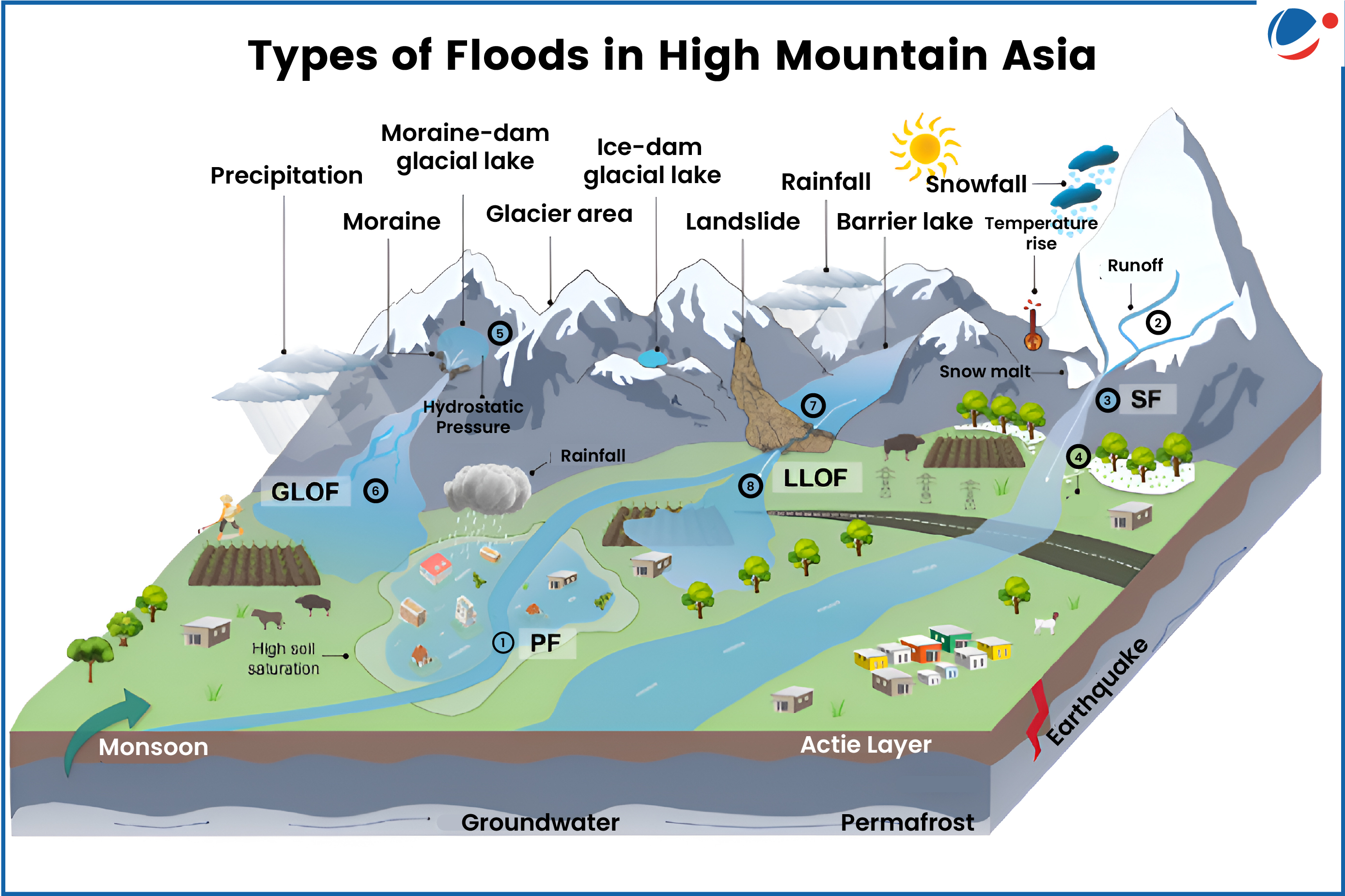
  • Rain/Pluvial Floods (PF): Triggered by extreme rainfall, leading to surface runoff and flash floods, common in Himalayas.
  • Snowmelt-induced floods (SF): Rising temperatures accelerate snowmelt, increasing river discharge, most frequent in Tien Shan.
  • Glacial Lake Outburst Floods (GLOFs): Caused by glacial lakes breaching due to melting glaciers or landslides, common in Karakoram and Himalayas.
  • Landslide-Dammed Lake Outburst Floods (LLOFs): Occur when landslides block rivers, forming temporary lakes that later breach, mostly in Hengduan Mountains.

Recommendations

  • Prioritise real-time flood monitoring in vulnerable valleys.
  • Strengthen data-sharing agreements between HMA nations to address transboundary threats
  • Promoting community-based flood mitigation efforts including locally-led construction of protective infrastructure etc.

About High Mountain Asia

  • HMA, also called the ‘Asian Water Tower’, is an important source of freshwater since it holds largest reservoir of frozen water outside the polar regions 
  • It feeds 10 major rivers and supporting more than 2 billion people.
  • It consists of Tibetan Plateau, surrounded by mountain ranges of Tien Shan, Pamir, Hindu Kush, and Karakoram in west, Himalayas in south and southeast, and Qilian Shan in east.
Watch Video News Today

Explore Related Content

Discover more articles, videos, and terms related to this topic

RELATED VIDEOS

2
Carbon Markets

Carbon Markets

YouTube HD
What is Artificial Rain? | Deep Dive With VisionIAS

What is Artificial Rain? | Deep Dive With VisionIAS

YouTube HD
Title is required. Maximum 500 characters.

Search Notes

Filter Notes

Loading your notes...
Searching your notes...
Loading more notes...
You've reached the end of your notes

No notes yet

Create your first note to get started.

No notes found

Try adjusting your search criteria or clear the search.

Saving...
Saved

Please select a subject.

Referenced Articles

linked

No references added yet