
Rockets struck in the Israeli-occupied Golan Heights.
About Golan Heights
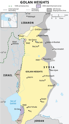
- Israel seized Golan Heights from Syria during Six-Day War (1967) and annexed it in 1981 (it’s not recognised internationally).
Key Geographical Features
- It’s a rocky plateau in south-western Syria.
- Golan is bounded by Jordan River and Sea of Galilee (west); Mount Hermon (north), seasonal Wadi Al-Ruqqād ( east), and Yarmūk River (south).
- It’s a key source of water for an arid region.
- The land is fertile; volcanic soil is used to cultivate vineyards.

