Why in the News?
Recently, Maharashtra government has approved the Wainganga-Nalganga river linking project.
More on the News
- Under the project, water from Wainganga (Gosikhurd) river in Godavari basin will be redirected to the Nalganga (Purna Tapi) project in Buldhana district by constructing 426.52km of link canals.
- The National Water Development Agency (NWDA) presented the detailed project report in 2018.
- It will supplement the National River Linking Project (NRLP).
- Maharashtra governor also approved the Nar-Par-Girna Valley Intra-State Link Project.
- Nar-Par-Girna Valley link project is an Intra-State link proposal of Maharashtra State
- It aims to divert the surplus waters from Maharashtra portion of west flowing river basins i.e. Ambika basin, Auranga basin and Nar-Par basins to east side i.e. Girna river of Tapi basin.
About Wainganga and Nalganga River
|
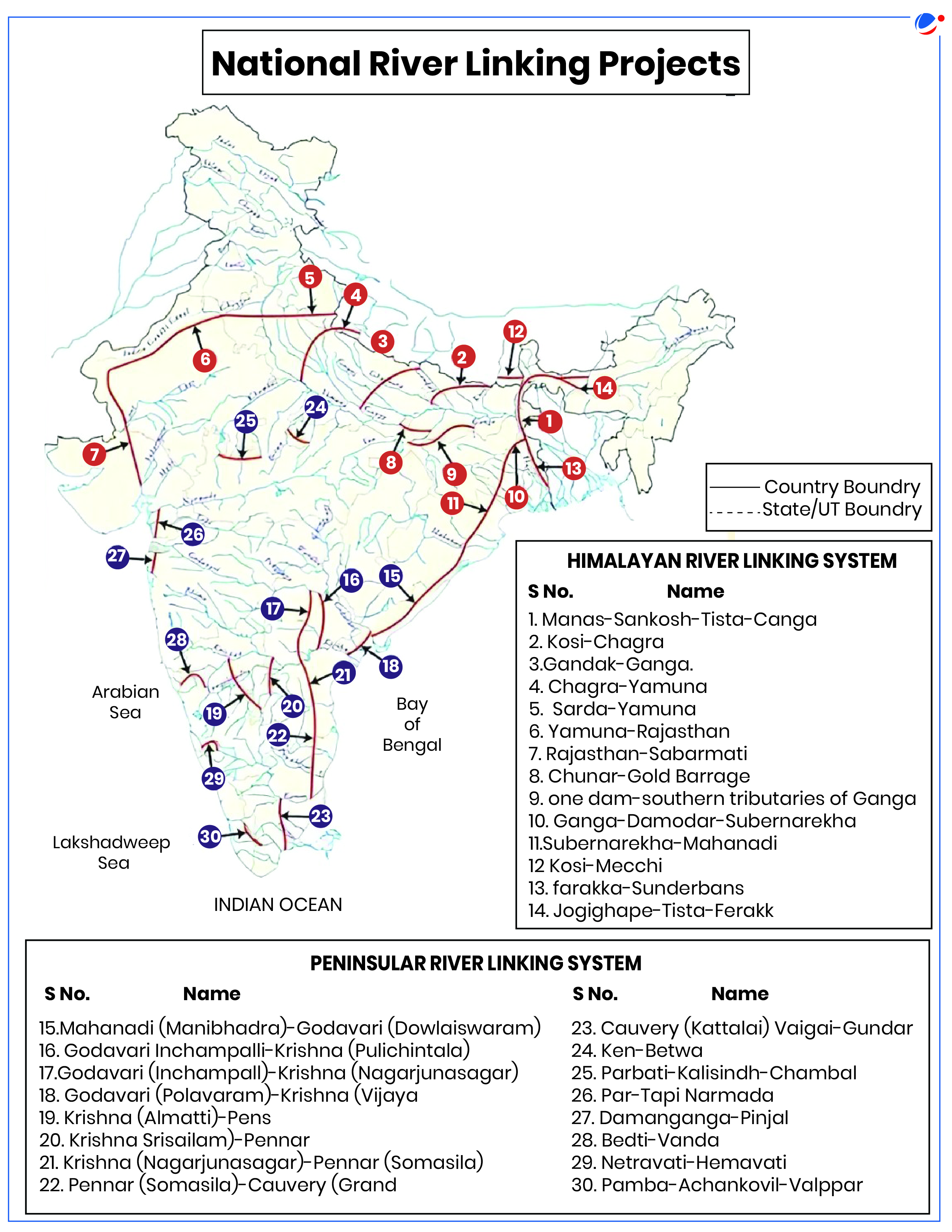
Interlinking of Rivers
- National River Linking Project (NRLP) aimed to link different surplus rivers of country with the deficient rivers so that the excess water from surplus region could be diverted to deficient region.
- Background: The National Perspective Plan (NPP) was prepared by the then Ministry of Irrigation (now Ministry of Jal Shakti) in August 1980.
- Under the NPP, the National Water Development Agency (NWDA) has identified 30 links (16 under Peninsular Component & 14 under Himalayan Component) for preparation of Feasibility Reports.
- In 2021, Union Cabinet approved the implementation of Ken Betwa river link - first interlinking of rivers project.
Benefits of Interlinking of Rivers
- Irrigation Facility: As per National Perspective Plan, the Interlinking of Rivers Projects aims to benefit 35 million hectares of irrigation (25 million ha from surface waters and 10 million ha by increased use of ground waters).
- Hydro power Generation: Help in generation of around 34000 Megawatt of hydro power (National Perspective Plan).
- Water Security: Increasing water availability for drinking and industrial purposes.
- As per NITI Aayog's Composite Water Management Index India is undergoing the worst water crisis in its history and nearly 600 million people are facing high to extreme water stress.
- Inland water ways: Once canals are built, they will also be used as waterways for navigation, reducing stress on road/rail transport.
- Tackle droughts and floods: As per World Meteorological Organisation, Economic losses in 2022 due to disasters relating to floods in India are estimated to be over US$ 4.2 billion.
- Others: Employment generation, Growth of Service sector, safe drinking water etc.
Challenges of Interlinking of Rivers
- State Water Dispute: Interlinking rivers requires consensus among states, which is difficult to achieve.
- Example-Cauvery water dispute between Tamil Nadu and Karnataka.
- Environmental Impact: Many experts believe that interlinking of rivers may lead to disturbance of very complex nature cycles that can have far-reaching adverse impact on monsoon cycles and biodiversity.
- For example, Ken River hosts a unique medicinal fish not found in Betwa. Diverting Ken's water to Betwa could disrupt local biodiversity, with unknown impacts on the native fish population.
- Loss of forests: The proposed Daudhan dam for Ken Betwa Link Project, is expected to put over 10 per cent of the tiger habitat of Panna Tiger Reserve under water.
- Social Cost: The Polavaram Link project, part of the interlinking of Mahanadi-Godavari-Krishna-Pennar-Cauvery-Vaigai rivers, has affected around 1 lakh families, with 80% being tribals.
- Bilateral Challenges: Himalayan rivers like the Ganga and Brahmaputra flow across multiple international boundaries.
- Economic cost: Like Wainganga-Nalganga river linking project will cost around ₹87,342.86 crore.
Government Steps
- Task Force for Interlinking of River: Ministry of Water Resources, River Development & Ganga Rejuvenation constituted in 2015 to look into the issues relating to Interlinking of Rivers.
- Special Committee for Interlinking of Rivers: Constituted in 2014, which formed 3 sub-committees
- Sub-Committee-I: Sub-Committee for Comprehensive Evaluation of various Studies/Reports available on the issues of ILR.
- Sub-Committee-II: Sub-Committee for System Studies for identification of most appropriate alternative plan.
- Sub-Committee-III: Sub-Committee for Restructuring of NWDA
- Group on Intra-state River Links: In 2015, a Group on Intra-State River Links was formed to review key issues, define intra-state links, and propose funding strategies for related projects.
- National Bank for Agriculture and Rural Development (NABARD) Funding: NABARD provides funding for the Accelerated Area Benefited Programme component of the Pradhan Mantri Krishi Sinchayee Yojana (PMKSY) through the Long Term Irrigation Fund.
Conclusion
The ILR project promises to revolutionize water distribution, boosting agriculture, employment, and overall development. By addressing water scarcity and promoting equitable resource allocation, it paves the way for a prosperous, sustainable future for New India.